Advances in
Geographical Research
Learn research methodology online with courses of Advanced Geospatial technologies, statistical methods, and Machine Learning algorithms. It is not just courses, we provide you with courses, tools, and data to start learning and advance your skills. We teach you the right skills to be prepared for tomorrow.

Advances in Geographical Research
A Government of India Registered Organization under MSME
MSME Registration No. UDYAM-WB-05-0002608
ISO 9001-2015 Certified
Certificate No : UKAAB/LHDPN1187V
Download the Android app from the play store: AIGR
https://play.google.com/store/apps/details?id=com.knorish.AIGR
Online Certificate Course
on
Understanding Urban Environment with GIS: Assessment & Modeling, of Environmental Impact
Lifetime AccessINR. 4999.00 USD. 75
Enroll nowRegistration is Open for
Online Certificate Course
On
Understanding Urban Environment with GIS
Assessment & Modeling of Environmental Impact
Understanding Urban Environment with GIS
Assessment & Modeling of Environmental Impact
A comprehensive training program on exploring, modeling, and analyzing urban landscapes with advanced geospatial techniques
Online Course
on
Advanced Multivariate Analysis with SPSS: Mastering Complex Data Interpretation for Informed Decision-Making
Date will announce soonINR. 2499.00 USD. 30.00
Enroll nowRegistration is Open for Online Course
On
Advanced Multivariate Analysis with SPSS: Mastering Complex Data Interpretation for Informed Decision-Making
Advanced Multivariate Analysis with SPSS: Mastering Complex Data Interpretation for Informed Decision-Making
Keywords: SPSS; Data Analysis ; Logistic Regression; SEM; Factor Analysis; Discriminant and Correspondence Analysis; Neural Network
Online Course
on
Statistical Data Analysis and Visualization With R Programming: From Basics to Advanced Analytics
INR. 4999.00 USD. 65.00
Enroll nowRegistration is Open for Online Course
On
Statistical Data Analysis and Visualization With R Programming
From Basics to Advanced Analytics
Statistical Data Analysis and Visualization With R Programming
From Basics to Advanced Analytics
Keywords: R Programming Course; Data Analysis with R; R Data Visualization; R Programming for Beginners
Online Course
on
Innovative Trend Analysis (ITA) for Environmental Monitoring: Using Excel, R, and ArcGIS
INR. 1999.00 USD. 30.00
Enroll nowRegistration is Open for Online Course
On
Innovative Trend Analysis (ITA) for Environmental Monitoring:
Using Excel, R, and ArcGIS
Innovative Trend Analysis (ITA) for Environmental Monitoring:
Using Excel, R, and ArcGIS

Online Course
on
Practical Training in Univariate and Bivariate Analysis with SPSS
INR. 1999.00 USD. 30.00
Enroll nowRegistration is Open for Online Course
On
Practical Training in Univariate and Bivariate Analysis with SPSS
Practical Training in Univariate and Bivariate Analysis with SPSS
Join our Online Workshop titled "Practical Training in Univariate and Bivariate Analysis with SPSS," offers an extensive curriculum aimed at providing participants with a comprehensive understanding of fundamental statistical concepts and their practical application using the SPSS software. The structured curriculum, organized over six days, covers a wide range of statistical techniques essential for data analysis. Each day focuses on specific topics: Day 1: Foundation: Introduction to statistics and familiarization with SPSS for data management. Day 2: Exploratory Data Analysis: Graphical representation, descriptive statistics, and distribution analyses. Day 3: Hypothesis Testing and Bivariate Analysis: Understanding various statistical tests and measures. Day 4: Correlation and Regression: Exploring correlation, simple and multiple regression, and their diagnostics. Day 5: Parametric Tests: T-tests, ANOVA, and ANCOVA for comparing means and variance. Day 6: Advanced Analysis: MANOVA, MANCOVA, and non-parametric tests for complex data analysis.
This workshop is designed to equip participants with a solid foundation in statistical analysis and the practical skills required to navigate and interpret data effectively using SPSS software. With a balanced mix of theoretical understanding and hands-on application, participants can expect to gain a versatile skill set in statistical analysis by the workshop's end.
Online Course
on
Machine Learning (ML) for Landslide Prediction Mapping with RStudio and ArcGIS
INR. 10000.00 USD. 150.00
Enroll nowRegistration is Open for Online Course
On
Machine Learning (ML) for Landslide Prediction Mapping with RStudio and ArcGIS
Machine Learning (ML) for Landslide Prediction Mapping with RStudio and ArcGIS

Online Course
on
Google Earth Engine (GEE) for Remote Sensing & GIS Analysis
Beginners to Advanced
INR. 6500.00 USD. 100.00
Enroll nowRegistration is Open for Online Course
On
Google Earth Engine (GEE) for Remote Sensing & GIS Analysis: Beginners to Advanced
Google Earth Engine (GEE) for Remote Sensing & GIS Analysis: Beginners to Advanced
The Google Earth Engine (GEE) for Remote Sensing & GIS Analysis: Beginners to Advanced workshop is designed to provide participants with an in-depth understanding of GEE and how to use it for remote sensing and GIS analysis. The workshop is suitable for individuals who are new to programming languages and Earth Engine functions, as well as those who have some experience but wish to enhance their skills and knowledge.
After finishing this course, you will be able to do any remote sensing analysis utilizing the Google Earth Engine Platform swiftly and efficiently. We will discuss basic GEE, calculating any indices, LULC mapping, air quality monitoring, time series analysis, supervised classification, machine learning methods, and other topics which are important for remote sensing analysis.

Registration is Open for Online Course
On
Mastering ArcGIS: From Beginner to Expert
Mastering ArcGIS: From Beginner to Expert
Keywords: 1. Overview ArcGIS 2. Datum and Projection 3. Data Types, Heads-up Digitization 4. Symbology & Labelling 5. Spatial Data Input and Editing6. Introduction to Database Management 7. Raster data 8. Vector data 9. Data Conversion 10. Sampling 11. Proximity 12. Geostatistical Analysis 13. Advanced Map Layout
Certificate Course
on
Landuse and Landcover (LULC) Mapping using Conventional and Machine Learning approaches and its Prediction by Cellular Automata Markov Chain model
INR. 6500.00 USD. 90.00
Enroll nowRegistration is Open for Certificate Course
On
Landuse and Landcover (LULC) Mapping using Conventional and Machine Learning approaches and its Prediction by Cellular Automata Markov Chain model
Landuse and Landcover (LULC) Mapping using Conventional and Machine Learning approaches and its Prediction by Cellular Automata Markov Chain model
Keywords: LULC; Supervised; Unsupervised; Combined Classification; RF; SVM; LULC Change detection; CA Markov Chain
Certificate Course
on
HYDRO-MORPHOMETRIC CHARACTERISTICS OF THE DRAINAGE BASIN IN ARCGIS
INR. 6500.00 USD. 90.00
Enroll nowRegistration is Open for Certificate Course
On
HYDRO-MORPHOMETRIC CHARACTERISTICS OF THE DRAINAGE BASIN IN ARCGIS
HYDRO-MORPHOMETRIC CHARACTERISTICS OF THE DRAINAGE BASIN IN ARCGIS
Keywords: Hydro-geomorphology, DEM, Morphometric analysis, Remote sensing, GIS, Visualization, Mapping and ArcGIS
Certificate Course
on
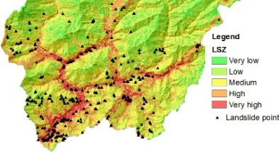
An Ensemble of Evidence Belief Function (EBF) with Frequency Ratio (FR) for GIS-based landslide prediction in Excel and ArcGIS
INR. 10000.00 USD. 150.00
Enroll nowRegistration is Open for Certificate Course
On
An Ensemble of Evidence Belief Function (EBF) with Frequency Ratio (FR) for GIS-based landslide prediction in Excel and ArcGIS
An Ensemble of Evidence Belief Function (EBF) with Frequency Ratio (FR) for GIS-based landslide prediction in Excel and ArcGIS
In this online workshop and live practice, you can learn the complete process (A-Z) from scratch to production. How to select parameters and why, download raster and vector data, processing data, images in ArcGIS environment, justification of variables, step by step guide of Dempster-Shafer theory of EBF and FR models, produced prediction map applying combined EBF and FR methods in Landslide prediction zonation using ArcGIS. Moreover, you will also learn validation of the susceptibility map using advanced techniques such as success rate curve and prediction rate curve.
After completing this course, you will be efficiently able to process, predict, and validate any data related to hazard, vulnerability, risk, and suitability assessment using the EBF and FR models.
Certificate Course
on
An Integrated MCDM approach for Drought Vulnerability Assessment in R, Excel and ArcGIS
INR. 10000.00
USD. 150.00
Registration is Open for Certificate Course
On
An Integrated MCDM approach for Drought Vulnerability Assessment in R, Excel and ArcGIS
An Integrated MCDM approach for Drought Vulnerability Assessment in R, Excel and ArcGIS
In this online workshop and live practice, you can learn the complete process (A-Z) from scratch to production. How to select parameters and why, download raster and vector data, processing data, images in ArcGIS environment, justification of variables, step by step guide of SPI, CRITIC, WASPAS, and SAW models in excel, produced prediction map applying CRITIC, WASPAS, and SAW methods in Drought Vulnerability zonation using ArcGIS. Moreover, you will also learn validation of the susceptibility map using advanced techniques such as MAE, MSE, RMSE, ROC-AUC.
After completing this course, you will be efficiently able to process, predict, and validate any data related to hazard, vulnerability, risk, and suitability assessment using the CRITIC, WASPAS, and SAW models.

Certificate Course on
Groundwater potentiality and stress zonation using TOPSIS, VIKOR and EDAS models in Excel and ArcGIS
INR. 10000.00
USD. 150
Registration is Open for Certificate Course
On
Groundwater potentiality and stress zonation using TOPSIS, VIKOR, and EDAS models in Exel and ArcGIS
In this online certificate course, you can learn the complete process (A-Z) from scratch to production. How to select parameters and why, download raster and vector data, processing data, images in ArcGIS environment, justification of variables, step by step guide of TOPSIS, VIKOR and EDAS in excel, produced prediction map applying these methods in groundwater potentiality and stress zonation using ArcGIS. Moreover, you will also learn validation of the potentiality map in ArcGIS software.
Registration is Open for Certificate Course on
Flood Hazards, Vulnerability and Risk Assessment using Analytical Hierarchy Process in Excel and ArcGIS
In this course, you can learn the complete process (A-Z) from scratch to production. How to select parameters and why, download raster and vector data, processing data, images in ArcGIS environment, justification of variables, step by step guide of Analytic Hierarchy Process (AHP) in excel, produced prediction map applying AHP method in hazard, vulnerability, and risk using GIS. Moreover, you can also learn sensitivity analysis in ArcGIS and validation of the susceptibility map in SPSS software.
Analytic Hierarchy Process (AHP) is the most powerful multi-criteria decision-making and Problem-Solving method first introduced by Saaty in 1980. In short, it is used for ranking the attributes to select the optimal attribute based on the hierarchical structure of goal at the top level, criteria at the second level, and alternative at third level
After completing this course, you will be efficiently able to process, predict, and validate any data related to hazard, vulnerability, risk, and suitability assessment using the Analytic Hierarchy Process (AHP).

Certificate Course
Flood Hazards, Vulnerability and Risk Assessment using Analytical Hierarchy Process in Excel and ArcGIS
INR. 10000.00
USD. 150

About AIGR
Advances in Geographical Research (AIGR) provides certified professional training, development opportunities and assured innovative research ideas for the next generation of researchers, such as programs and courses in research methodology, Remote sensing, Geo-Informatics and GIS courses, as well as mentoring.
Our motto is making the complex simple. Led by some of the world’s leading researchers, who provide key insights from their experience, our training programs support career development and encourage our researchers to excel in their field.
Learn moreCourse option


Why Learn With us?
Over two decades of experience and expertise in Geospatial science and research helping students develop their tech skills for higher performance, better careers, and growth in companies.
Read More
Why Learning With us?
World Class Teachers
Get certified with our premium courses and get started on your journey to a brand new career altogether
Certifications
Get certified with our premium courses and get started on your journey to a brand new career altogether
Students Community
Get certified with our premium courses and get started on your journey to a brand new career altogether
Live session
Get certified with our premium courses and get started on your journey to a brand new career altogether
Courses

Cooming Soon
Remote Sensing for Beginners
Become proficient in satellite remote sensing, spatial analysis principles, methods, applications, sensors, and GIS!
₹ 1000.00
$ 20.00
Cooming Soon
Excel Visualization
Master 50+ Excel charts, build advanced Excel visuals & learn data analysis with a top Excel instructor
₹ 500.00
$ 10.00

Cooming Soon
Prediction Mapping Using ML Algorithms
eXtreme Gradient Boosting, K Nearest Neighbour, Naïve Bayes, Random Forest for Prediction Geo-Hazards and Risk
₹ 10000.00
$ 200.00
World class Teachers

Dr. Baidyanath Pal
Associate Scientist C
Indian Statistical Institute (ISI)
Expert in Statistics
Software Skills: SPSS, AMOS, R, R-studio, STRATA

Mr. Sujit Kumar Roy
Research Assistant, Bangladesh University of Engineering and Technology (BUET)
Expert in Machine Learning and Deep Learning
Software Skills: ArcGIS, QGIS, R/R-Studio, Python, Google Earth Engine

Dr. Tapash Mandal
Research Trainer at AIGR
Expert in LULC, spatial modeling
Software Skills: ArcGIS, QGIS, Geometica, Erdas Imagine, Terrset, SWAT

Dr. A.T.M. Sakiur Rahaman
RIKEN, Kobe, Japan
Expert in Machine learning and
process-based models
Software Skills: ArcGIS, QGIS, R, R-studio, Python, WAKA, Google Earth Engine, HecRAS, GeoHecRAS, SWAT model

Dr. Pooja Gupta
Rani Durgawati Viswavidyalaya, Jabalpur, India
Expert in Remote sensing and GIS application on Geoinformatics for
disaster management
Software Skills: ArcGIS, QGIS, WebGIS, Mapinfo, Global Mapper, Google Earth Engine, Geometica

Dr. Sankar Biswas
Ph.D. in Geography
Expert in visualization,
Statistics and Modelling
Software Skills: Excel, Power BI, SPSS, STRATA, GraphPad Prism, JMP, SAS, MATLAB, R-studio, ArcGIS
What students say about us

Robert Peter Zakayo Galla
- Designation: Hydrologist and Geo-Spatial Analyst
- Country: South Sudan
- Subject: Hydrology
- Course: Hazards, Vulnerability and Risk Assessment using Analytical Hierarchy Process in ArcGIS
- Feedback: “The workshop content is very good and the instructor is knowledgeable enough to teach the content of the course. The course benefits a lot of scientist and researcher, give them the guide to conduct scientific research related to flood susceptibility and risk. As such the course is very satisfactory.”

Kemela Barakumo
- Designation: Student
- Country: Nigeria
- Subject: Geography & Environmental Management
- Course: Hazards, Vulnerability and Risk Assessment using Analytical Hierarchy Process in ArcGIS
- Feedback: “The workshop has been informative and has added much to my library as a beginner in geo-information. I must commend the efforts of the instructor, Dr. Das, he has been phenomenal (a good tutor) & I look forward to having more interactions with Advances in Geographical Research especially with the likes of Dr. Das. Thank you, Advances in Geographical Research, thank you Dr. Das & Stay blessed.”

Chitikela N Vara Laxmi
- Designation: Assistant Professor
- Country: India
- Subject: Remote Sensing
- Course: Hazards, Vulnerability and Risk Assessment using Analytical Hierarchy Process in ArcGIS
- Feedback: “It was a fabulous workshop with great sessions. I learned a lot of new things from this workshop, the content was extremely informative and incredibly useful. I would like to thank you Dr. Das sir for wonderful live practice classes and 1:1 problem solving classes. He explained every step of process in detail with lot of patience. Totally loved your sessions sir.”

Enike Poni Elliaba Mada
- Designation: Hydrologist and Geo-Spatial Analyst
- Country: South Sudan
- Subject: Flood susceptibility, vulnerability Analysis
- Course: Multicriteria Decision Making using Analytical Hierarchy Process in ArcGIS: Geo-hazards, vulnerability and Risk Assessment
- Feedback: “The contents of the workshop are well constructed, articulated and interesting. The instructor is good a facilitator, he demonstrates well and he is knowledgeable of the topic. I have benefited and satisfied a lot of knowledge from the workshop. I will be following your website get more knowledge on GIS”

Shyam Lochan Bora
- Designation: Assistant Professor
- Country: India
- Subject: Physics
- Course: Hazards, Vulnerability and Risk Assessment using Analytical Hierarchy Process in ArcGIS
- Feedback: “Indeed, a great workshop. I am a beginner in this field and now I am confident that I can do something in this very short duration. I am very grateful to the organising team and the mentor. I will definitely join each and every upcoming course. And the last but not the least Till now I have never attended any workshop where the mentor asks about the problems encountered by participants in regular basis and ready to give one to one discussion. In one word, it is a fabulous workshop”

Sunil Kumar Patel
- Designation: Research Scholar
- Country: India
- Subject: Geology
- Course: Hazards, Vulnerability and Risk Assessment using Analytical Hierarchy Process in ArcGIS
- Feedback: “The content of course is very nice which covers many aspects provides us valuable knowledge in our research work. As before the workshop I studied many papers related to AHP but not understood. But after this workshop, AHP method is understood well as you instruct this difficult topic in a very simple and scientific way. This workshop covers a various important parameters which is necessary for any research work. As in my study area, the lower basin is highly susceptible and vulnerable zone related to flood. This workshop made me able to work on flood by this MCDM and AHP process. I am highly satisfied by this workshop”. Thank You