Online Training Program | Lifetime Access
Registration is open
Google Earth Engine (GEE)
for Remote Sensing & GIS Analysis: Beginners to Advanced
"Google Earth Engine (GEE) for Remote Sensing & GIS Analysis: Beginners to Advanced" lies in its comprehensive coverage of GEE, from the basics to advanced techniques. Learners can gain hands-on experience in using GEE for remote sensing and GIS analysis, making it an ideal course for beginners and professionals alike. Enrolling in this course can help learners enhance their skill sets and excel in their careers.
ABOUT Online Course
Are you interested in learning the fundamentals of GEE? Do you want to understand how to use GEE to create maps, analyze data, and solve real-world problems? If so, this course is perfect for you!
The Google Earth Engine (GEE) for Remote Sensing & GIS Analysis: Beginners to Advanced workshop is designed to provide participants with an in-depth understanding of GEE and how to use it for remote sensing and GIS analysis. The workshop is suitable for individuals who are new to programming languages and Earth Engine functions, as well as those who have some experience but wish to enhance their skills and knowledge.
After finishing this course, you will be able to do any remote sensing analysis utilizing the Google Earth Engine Platform swiftly and efficiently. We will discuss basic GEE, calculating any indices, LULC mapping, air quality monitoring, time series analysis, supervised classification, machine learning methods, and other topics which are important for remote sensing analysis.
- 1. Introduction to Google Earth Engine
- 2. Setting up the Environment
- 3. Sign-up for Google Earth Engine
- 4. Introduction to Remote Sensing
- 5. JavaScript programming language A to Z
- 6. Filtering Image Collections
- 7. Creating Mosaics and Composites from Image Collections
- 8. Working with Feature Collections
- 9. Importing Data: Raster and Vector Data
- 1. Earth Engine Objects
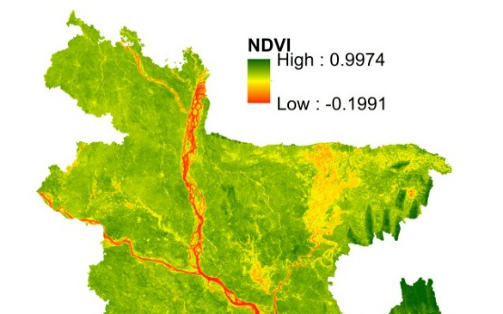
- 2. Calculating Indices: NDVI, NDWI, NDBI, BI, EMBI and other indices
- 3. Computation on Image Collections: Area, Date
- 4. Cloud Masking
- 5. Reducers
- 6. Time-Series Charts of NDVI over a period of time
- 7. Visualization (DEM) of Elevation, Hill shade and Slope Map using NASA SRTM
- 8. Exporting Data
- 9. Map Layout (Add Legend, Title in your Map)
- 1. Unsupervised Classification
- 2. Basic Supervised Classification
- 3. Introduction to Machine Learning and Supervised Classification
- 4. Landuse and Landover Classification Map/LULC
- 5. Accuracy Assessment
- 6. Improving the Classification
- 7. Exporting Classification Results
- 8. Calculating Area
- 1. Nitrogen Dioxide (mol/m^2) Mapping
- 2. Sulphur Dioxide (moll/m^2) Mapping
- 3. Carbon monoxide (CO) Mapping
- 4. Methane (CH4) Mapping
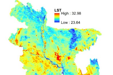
- 5. LST (Land Surface Temperature) Mapping
- 1. Temperature Condition Index (TCI)
- 2. Vegetation Condition Index (VCI)
- 3. Vegetation Health Index (VHI)
Primary Trainer
Primary Trainer Mr. Sujit Kumar Roy is a Research Assistant at GAZI GROUP. He has over 5 years of working experience in the field of EIA, RS and GIS for different national (Government) and international projects as post of GIS analyst at Suchana Engineers Limited, Research Assistant at IWFM, BUET, Research Fellow at RAiN Forum, Junior Environmental Expert at Plan Plus Limited (PPL). He is currently pursuing a Post-Graduation in Water Resources Development from IWFM, BUET, Bangladesh and has a Bachelor’s degree in Environmental Science and Disaster Management from Noakhali Science and Technology University (NSTU). Furthermore, he is an independent researcher with a variety of software experts who have published several scientific articles in internationally renowned journals highlighting his areas of interest, which include RS and GIS, Hydrology, Time Series, Natural Hazards, Coastal Zone Management, Machine Learning, and Deep Learning. He is engaged in different environmental research and its advancement.
Trainer
Training Benefits
- The workshop helps participants develop their GEE skills from beginner to expert level.
- The workshop covers various GEE functionalities, including data management, analysis, visualization, and sharing.
- Instructors' continuous support, taking your hand step-by-step to develop high-quality prediction maps using real data.
- Live WhatsApp Chatting with the instructor
- 1:1 Sessions with experts
- Lifetime subscription
- Any time watch the recorded video
- Easy Payment Gateway such as Debit card, credit card, UPI etc. (international payment also acceptable by STRIPE payment gateway)
Ready to enroll Online Course ?
GOOGLE EARTH ENGINE (GEE) FOR REMOTE SENSING & GIS ANALYSIS: BEGINNERS TO ADVANCED
Why Learn With us?
Over two decades of experience and expertise in teaching Tech and coding helping students develop their tech skills for higher performance, better careers and growth in companies.

Benefit of taking this course?
World Class Teachers
Get certified with our premium courses and get started on your journey to a brand new career altogether
Certifications
Get certified with our premium courses and get started on your journey to a brand new career altogether
Students Community
Get certified with our premium courses and get started on your journey to a brand new career altogether
Live session
Get certified with our premium courses and get started on your journey to a brand new career altogether